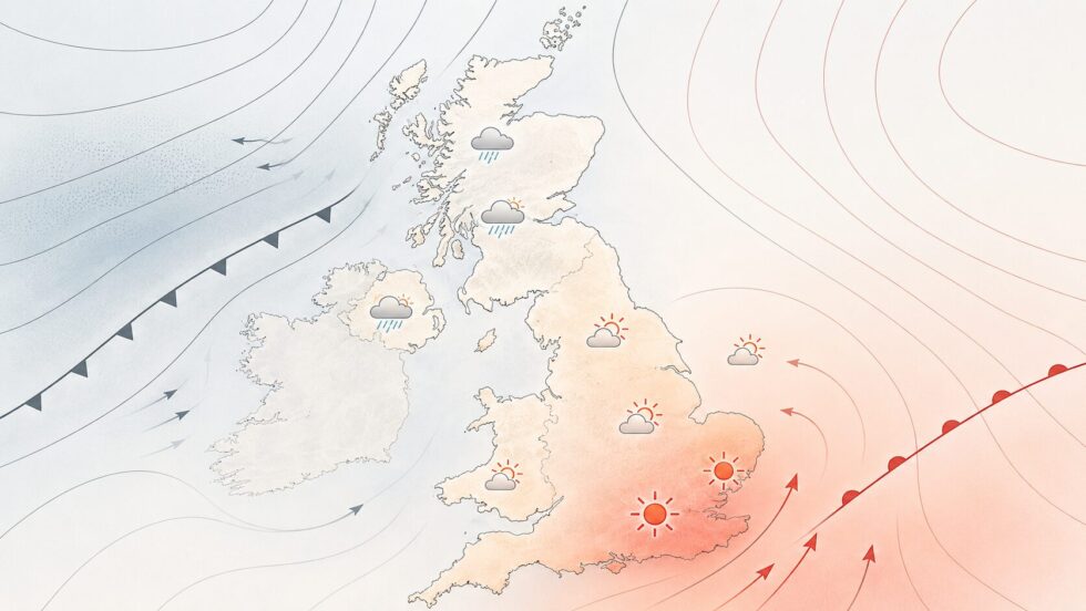
UK weather forecast from Tuesday, 16 June, points to a clear shift after a cooler and unsettled start to the month: summer warmth is expected to return in bursts, with London and parts of south-east England likely to see the highest temperatures, while Scotland and Northern Ireland remain closer to Atlantic cloud, showers and fresher air. The WP Times reports, citing the Met Office, that the pattern from mid-June is not a simple “heatwave everywhere” story, but a battleground between warmer continental air from the south and low pressure still sitting to the north-west of the UK.
From 16 June to the end of the month, the most important period for households, commuters, older people, hay fever sufferers and event organisers is likely to be 17–22 June, when yellow heat-health alerts are in force for London, the South East, the East of England and the East Midlands. The Met Office long-range outlook then suggests that from 20–29 June the south and south-east could stay very warm and humid at times, with thunderstorm risk, before high pressure near the UK around 30 June and 1 July brings mainly dry and settled weather, though confidence falls as July begins.
What changes from 16 June: warmer air returns, but not evenly across the UK
The return of summer warmth starts after a week in which much of the country felt cooler, wetter and more unsettled than many people expect in mid-June. The Met Office had already signalled a warmer and more settled weekend after the unsettled spell, with temperatures reaching the mid-20s Celsius in some areas and high pressure building from the south. That same pattern then continues into the working week, but with important regional differences: the south and east benefit most from warmer air, while the north and west stay more exposed to cloud and rain.
For London, the change is especially noticeable. Forecast data for the capital shows Tuesday, 16 June, becoming warm and pleasant, with highs around 25C, followed by a warmer spell later in the week and possible highs near 29C by Friday, 19 June. Sunday, 21 June, currently looks even hotter in London, with forecast highs above 30C, though local cloud, wind direction and shower development can still change the exact figure.
In Scotland, the picture is less dramatic but still warmer than the start of June. Edinburgh is forecast to move from around 18C on Tuesday, 16 June, to around 20C by Wednesday and again near 20C over the weekend, with showers possible on several days. This means Scotland is not excluded from the warmer trend, but it is less likely to see the same heat intensity as London, East Anglia or south-east England. Northern Ireland also sits on the more changeable side of the set-up. Belfast is forecast to see temperatures around 19–20C between 16 and 18 June, but with cloud, showers and breezier conditions still in the mix. That is mild and sometimes warm by local standards, but it is not the same as the hot, dry feel expected in parts of the south-east.
London and south-east England: where the heat risk is strongest
London is one of the areas most likely to feel the strongest burst of summer heat. UKHSA data shows a yellow heat-health alert for London, the South East, East of England and East Midlands from 3pm on Wednesday, 17 June, until 8pm on Monday, 22 June. The alert system is designed for health and social care planning when temperatures may affect the wellbeing of the population, especially older people, those with long-term conditions, young children and people in poorly ventilated homes.
This does not mean every day will be cloudless or that every part of London will reach the same temperature. Urban heat can vary sharply between shaded parks, exposed roads, flats with poor ventilation and dense built-up areas. But the combination of warmer nights, higher daytime temperatures and humidity can make the period more tiring than a single hot afternoon. For commuters, the most uncomfortable times may be late afternoon journeys, crowded public transport and warm overnight conditions in flats.
The practical message for London from 17–22 June is simple: treat the heat as a health issue, not only a lifestyle story. People should plan water, shade and cooling at home, especially if they live in top-floor flats or homes that retain heat. The hottest part of the day is usually not the best time for intense running, long walks with children, outdoor work or heavy travel with luggage. If the temperature climbs close to or above 30C, small decisions — curtains closed during the day, windows managed carefully, cold drinks prepared, medication checked — become more important. The south-east may also be at higher thunderstorm risk later in the period if hotter air pushes northwards and meets more unstable conditions. The Met Office long-range forecast for 20–29 June specifically notes the possibility of very warm and humid weather in parts of south and south-east Britain at the start of the period, with a chance of thunderstorms. That means the forecast is not simply “sun and heat”; it is heat with humidity, changing cloud and possible heavy showers in places.
Scotland and Northern Ireland: warmer, but more Atlantic influence
Scotland and Northern Ireland are likely to feel summer returning more softly than London. Western Scotland, Northern Ireland and north-western parts of the UK remain closer to the Atlantic low-pressure influence, which means more cloud, showers and occasional rain bands can still break through. The Met Office has described the wider UK pattern as one where southern and south-eastern areas are likely to have longer dry and warm spells, while the north and west see more cloud and rain.
For Belfast, the period from 16–21 June looks mild to warm but frequently cloudy, with showers possible on several days. Daytime highs around 18–20C are comfortable rather than hot, and the main issue is not extreme heat but changeability. People planning outdoor work, school events, travel or coastal trips should not read the London forecast as a UK-wide forecast. Northern Ireland can be warmer than last week and still have showers, grey spells and breezy conditions.
For Edinburgh and eastern Scotland, temperatures around 18–20C are expected through much of the same period, with a mix of cloud, sunny breaks and showers. This is a classic split-weather June pattern: warm enough to feel seasonal when the sun appears, but not settled enough to rely on a dry day without checking the local forecast. The further west and north one goes in Scotland, the more the Atlantic influence is likely to matter. The Met Office long-range outlook from 20–29 June does offer some improvement later in the month, with a signal for high pressure to build more widely toward the latter part of June. If that happens, Scotland and Northern Ireland may see more settled windows too. But the same outlook also warns that Atlantic low pressure may still bring brief spells of wet and windy weather, so confidence is lower than for the near-term London heat signal.
Key dates from 16 June to 1 July
| Date / period | Main signal | London / South East | Scotland | Northern Ireland |
|---|---|---|---|---|
| Tuesday 16 June | Warmer start after unsettled spell | Warm, around mid-20s possible in London | Milder, showers possible | Cloudy, showers possible |
| Wednesday 17 June | Heat-health alert begins in England regions | Yellow alert starts 3pm | Changeable, some showers | Breezy/cloudy, showers |
| Thursday 18 June | Heat builds in south/east | London may reach upper 20s | Milder, cloud/showers | Cloud/showers |
| Friday 19 June | Main heat pulse likely | London may approach 29C | Around 20C in Edinburgh | Around 19C in Belfast |
| Saturday 20 June | Long-range period begins | Warm/humid; thunderstorm risk possible | Mixed but milder | Mixed, not as hot |
| Sunday 21 June | Hotter in London possible | Forecast shows potential above 30C | Around 20C possible | Around mid/high teens |
| 17–22 June | UKHSA yellow heat-health alert | London, South East, East of England, East Midlands affected | No UKHSA heat alert shown for Scotland | UKHSA HHA applies to England, not NI |
| 20–29 June | Very warm/humid risk in south-east; high pressure may build later | Best chance of heat and humidity | Could become more settled later | Could improve later but changeable risk remains |
| 30 June–1 July | High pressure close to UK at start of period | Mainly dry, above-normal temperatures possible | More settled possible, confidence lower | More settled possible, confidence lower |
Why rain is still in the forecast
The most important weather detail is the clash between high pressure over or near continental Europe and low pressure near the north-west of the UK. High pressure to the south and east helps draw warmer air northwards and can bring drier, sunnier conditions. Low pressure to the north-west keeps the door open to showers, cloud and rain, especially for Scotland, Northern Ireland, Wales and north-west England.
This is why a UK-wide headline such as “summer heat returns” can be true and still incomplete. London may feel hot and humid while Belfast has cloud and showers. East Anglia may sit closer to the warmest air while western Scotland remains under more changeable Atlantic influence. The forecast is not contradictory; it is regional.
From 20–29 June, the Met Office expects the south and south-east to have the clearest chance of very warm and humid weather at the start of the period, with a possible thunderstorm risk. Later in June, high pressure may build more widely, which would increase the chance of drier and more settled weather for more parts of the UK. But the same forecast keeps the possibility of Atlantic wet and windy spells, meaning people should avoid treating the whole second half of June as guaranteed dry sunshine. For 30 June to 1 July, the long-range signal is more settled at first. The Met Office says high pressure is expected to lie close to the UK at the start of the 30 June–14 July period, bringing mainly dry, settled weather and above-normal temperatures. The south has the greatest chance of hot conditions and occasional thunderstorms, while into July the pattern may become less settled again if high pressure weakens or shifts north.
Heat-health alert: what yellow means for London
The yellow heat-health alert is not a dramatic red warning, but it is still important. UKHSA says the alerting system gives early warning when adverse temperatures are likely to affect health and wellbeing, and the current alert covers London, the South East, East of England and East Midlands from 17 to 22 June. For the public, this means vulnerable people may need practical support before the hottest hours arrive. Older neighbours, people living alone, people with heart or lung conditions, babies, outdoor workers and those in overheated housing can be affected before the weather feels “extreme” to healthy adults. Heat stress is often cumulative: a warm night after a hot day can be more difficult than the daytime temperature alone suggests.
Useful steps include drinking enough water, avoiding the strongest sun, reducing intense exercise during peak heat, checking indoor temperatures and keeping curtains closed when direct sun hits windows. People travelling across London should also plan for delays, crowded transport and warm platforms. For events, schools, care homes and workplaces, the alert is a reminder to prepare shade, water and rest breaks rather than reacting only when people feel unwell.
The alert currently applies to selected English regions, not to Scotland or Northern Ireland. That does not mean those nations have no weather risk; it means the UKHSA heat-health alerting system shown here is focused on England, while Scotland and Northern Ireland should be assessed through their own local weather and health guidance.
Pollen, hay fever and why warm weather may feel worse
The return of warmth comes after wet weather, and that matters for pollen. Grass pollen season is near its peak in June, and warmer, sunnier, breezier days can raise pollen levels quickly after rain has helped suppress them. For hay fever sufferers, the change from damp and unsettled to warm and brighter can bring sneezing, itchy eyes, blocked noses and fatigue. London can be particularly difficult because pollen mixes with urban pollution, traffic corridors and warm stagnant air. Parks, railway embankments, riverside paths and suburban gardens can all become triggers in the late afternoon or evening. People who react strongly to grass pollen should check daily pollen forecasts, keep windows closed during high-pollen periods, shower after outdoor exercise and avoid drying bedding outside on high-pollen days.
In Scotland and Northern Ireland, pollen risk can still rise during warmer dry windows, but rain and wind may interrupt it more often. That does not remove the risk; it simply makes it more variable. A dry, sunny afternoon after morning showers can still be difficult for allergy sufferers. The key point is that “better weather” is not better for everyone. For people with hay fever, asthma or respiratory sensitivity, warm and humid conditions can be physically demanding, especially if thunderstorm risk increases later in the month.
Not every hot spell is officially a heatwave. In the UK, heatwave thresholds vary by county and require daily maximum temperatures to meet or exceed the local threshold for three consecutive days. London and parts of south-east England have higher thresholds than many other regions because they are climatologically warmer. Based on the current pattern, London and south-east England have the best chance of reaching heatwave-like conditions, especially if temperatures stay high from Thursday through the weekend. But the exact answer depends on observed temperatures, not only forecasts. Cloud cover, wind direction, thunderstorms and the timing of continental air can all shift the final outcome by a few degrees.
For Scotland and Northern Ireland, the current signal is much less supportive of an official heatwave. Temperatures are expected to become milder or warmer, but not broadly hot in the same way as the south-east. The north and west also remain more exposed to Atlantic cloud and showers, reducing the likelihood of three consecutive hot days. So the careful wording is this: the UK is entering a warmer spell, London and the south-east may see hot conditions, and a heatwave is possible in some places if the temperature thresholds are met. But this is not, at this stage, a uniform UK-wide heatwave.
What to watch between 22 June and 1 July
After the first hot spell, attention turns to whether the heat reloads or fades. The Met Office long-range forecast for 20–29 June says there is a signal for high pressure to build more widely later in June, probably bringing drier and more settled conditions with temperatures above average for most. It also notes that hot conditions could return northwards with thunderstorm risk, depending on the position of high pressure.
That matters for London because a second push of heat would increase the chance of another uncomfortable urban spell. If humidity rises too, nights may become harder for sleep, especially in flats and houses that do not cool quickly. For outdoor events, this is a period where organisers should monitor both heat and thunderstorm risk, because the two can appear in the same forecast window.
For Scotland and Northern Ireland, the late-June signal is more cautiously positive. A wider build of high pressure could bring drier, calmer days and more sunshine than the first half of June. But if Atlantic systems still push in from the west, the improvement may come in windows rather than as a fully settled period.
For 30 June and 1 July, the Met Office expects high pressure close to the UK at the start of the 30 June–14 July period. That supports mainly dry and settled weather at first, with above-normal temperatures and the chance of hot conditions or thunderstorms especially in the south. Into July, confidence lowers, and the risk of more unsettled weather increases again if high pressure weakens or shifts.
Mercury retrograde: when it starts in this period
For readers following astrology, Mercury retrograde begins during this weather window. CHANI lists Mercury’s pre-retrograde shadow as beginning on 12 June 2026, with Mercury stationing retrograde on 29 June 2026 and stationing direct on 23 July 2026. The Old Farmer’s Almanac also lists the next Mercury retrograde as starting on 29 June 2026 and lasting until 23 July 2026.
This is not a meteorological factor and does not affect the Met Office forecast. But culturally, it may be relevant for readers who connect Mercury retrograde with travel delays, communication problems, technology issues and planning mistakes. The practical overlap is that late June already requires careful travel planning because of heat, possible thunderstorms and regional weather differences.
For a London reader, the sensible non-mystical advice is the same: check transport before leaving, keep water with you, avoid last-minute assumptions about the weather and do not rely on one national headline. A hot day in London can coincide with showers in Northern Ireland and a mixed day in Scotland.
The retrograde period starts just as the weather may move into a more settled but still humid and potentially stormy phase. That makes 29 June to 1 July a period to watch for both weather updates and travel planning, especially if people are moving between London, airports, Scotland, Northern Ireland or major outdoor events.
Practical forecast: what people should do now
For London and south-east England, prepare for heat from Wednesday, 17 June, with the strongest discomfort likely from Thursday into the weekend if current signals hold. Keep homes cool early, plan hydration, avoid unnecessary exposure during peak heat and check on vulnerable people. If thunderstorms appear in local forecasts, do not assume a hot day will stay dry. For Scotland, expect a warmer but mixed pattern. Edinburgh and eastern Scotland may see useful sunny breaks and temperatures around 18–20C, but showers remain part of the picture. Western Scotland is more likely to feel the Atlantic influence, especially if low pressure pushes cloud and rain across the north-west.
For Northern Ireland, plan for mild, cloudy and showery conditions rather than strong heat. Belfast may reach around 19–20C on some days, but the period is more changeable than hot. Outdoor plans should include rain options, especially around 16–20 June. For the whole UK, the message from 16 June to 1 July is balance. Summer warmth is returning, but it is uneven, humid at times and not free from rain. London may feel close to high summer; Scotland and Northern Ireland may feel more like a warmer version of a changeable June. The forecast improves compared with the cool start of the month, but it still needs daily checking because the UK is sitting between continental heat and Atlantic instability.
Read about the life of Westminster and Pimlico district, London and the world. 24/7 news with fresh and useful updates on culture, business, technology and city life: How Long Do Crypto Firms Have to Apply for FCA Authorisation Before the 2027 Deadline