Friday, 30 January 2026 — UK snow forecast remains a central concern as the aftermath of Storm Chandra continues to destabilise weather conditions across large parts of the UK, including South West England, London and the South East, Northern Ireland, northern England and Scotland. Although peak wind gusts of 60–70 mph recorded earlier in the week have eased, brisk southeasterly winds of 25–40 mph are still expected in exposed areas, particularly across Northern Ireland and western coastal regions.
The storm has left river catchments fully saturated, groundwater levels at seasonal or near-record highs and key transport corridors increasingly vulnerable, according to forecasters. The Met Office warns that even relatively moderate rainfall totals of 10–15 mm could now trigger disproportionate flooding impacts, especially in flood-prone areas such as the Somerset Levels and parts of southern England. At the same time, an influx of colder air across northern regions is introducing renewed snow and ice risks, with hill snow expected over the Pennines and Scottish Highlands, raising concerns over icy roads and further travel disruption, reports The WP Times, citing the Met Office.
Met Office warnings in force: scale and timing
The Met Office has issued multiple yellow weather warnings for Friday, 30 January, covering large parts of the UK as the lingering effects of Storm Chandra continue to raise the risk of flooding, travel disruption and localised snow. The warnings are in force across South West England, London and the South East, and Northern Ireland, with forecasters cautioning that the timing of rainfall and wind coinciding with peak travel periods could amplify impacts despite rainfall totals that would normally be considered moderate. As of early Friday, the Met Office has multiple yellow weather warnings active, covering:
- South West England
- London and South East England
- Northern Ireland (entire region)
Forecasters expect 10–25 mm of rain in many areas within 12–18 hours, with locally higher totals of 40–60 mm over hills, particularly across Antrim and Down. Given that soils in parts of southern England are already close to 100% saturation, runoff into rivers is expected to be rapid, raising the risk of flash flooding and surface water accumulation.
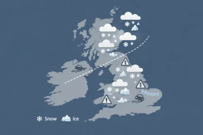
UK snow forecast: where snow is most likely
While heavy rain remains the primary hazard, the UK snow forecast for Friday 30 January points to localised but potentially disruptive snowfall, concentrated mainly over higher ground in northern Britain as colder air undercuts lingering moisture from Storm Chandra.
In the Scottish Highlands, snow is expected to accumulate above 250–300 metres, with 5–10 cm possible on the highest routes, including exposed passes. Daytime temperatures are forecast to remain between –1°C and +1°C, increasing the likelihood of persistent lying snow and icy surfaces, particularly on untreated roads.
Across the Pennines, hill snow is likely, especially during the early morning and late evening, when temperatures dip close to freezing. Even brief snowfall here could lead to hazardous driving conditions, with drifting snow possible in stronger gusts.
In northeast England, precipitation is expected to fall as a rain–snow mix, with transient snow showers turning heavier at times over elevated areas. Where skies clear overnight, icy patches are likely to form, posing risks for commuters and pedestrians. By contrast, lowland southern England is expected to see rain almost exclusively, as temperatures stay above freezing. However, forecasters caution that brief sleet or wet snow cannot be ruled out overnight in isolated locations if colder air edges further south than currently forecast.
Flooding risk: why impacts could worsen despite easing rainfall
Flood risk across the UK remains elevated not simply because of rainfall intensity, but due to the cumulative hydrological impact of Storm Chandra, which has already pushed river systems and flood defences close to their limits. Several locations recorded January daily rainfall totals well above long-term averages, leaving catchments highly sensitive to even modest additional precipitation. According to the Met Office, the primary concern now is not how hard it rains, but how little capacity the landscape has left to absorb it. Key risk factors include:
- Rivers already running above seasonal averages, reducing their ability to accommodate further runoff
- Flood plains, particularly across the Somerset Levels, remaining saturated after days of prolonged rainfall
- High tide cycles increasing the risk of backflow and drainage failure in coastal and low-lying catchments
Emergency planners warn that as little as 10 mm of additional rain in vulnerable areas could be enough to trigger renewed flooding, leading to road closures, transport disruption and, in some cases, precautionary evacuations. The risk is heightened where rainfall coincides with peak river levels or tidal surges, meaning impacts may escalate rapidly and with limited warning.
Somerset: major incident status explained
A major incident remains active in Somerset, coordinated by Somerset Council, the Environment Agency and emergency services. The declaration reflects not only the scale of flooding but also its duration. Local residents report water depths approaching those seen during the 2014 floods, when some homes experienced up to 90 cm (3 ft) of internal flooding. Temporary flood defences remain in place, and pumping operations are ongoing to protect residential areas and key transport routes.
Transport disruption: what travellers should expect
The Met Office and transport authorities warn of continued disruption across all modes:
- Roads: flooded A- and B-roads, especially in rural southwest England
- Rail: delays and cancellations on regional lines due to waterlogged tracks
- Air & ferries: knock-on delays from strong winds and reduced visibility
Drivers are advised to avoid floodwater, as just 30 cm of moving water can float a car, while rail passengers should expect rolling service updates throughout the day.
Regional outlook for Friday 30 January
South West England
Conditions remain particularly unsettled across the South West, where persistent rain, locally heavy at times, is expected to continue through much of Friday. With ground already saturated after Storm Chandra, flood warnings are likely to remain in place into the evening, especially in low-lying and rural areas. Surface water flooding may develop quickly during heavier downpours, while river levels are expected to respond rapidly to even short bursts of rain.
London and South East England
Across London and the South East, bands of rain will move steadily eastwards, occasionally becoming intense. Although rainfall totals may be lower than in western regions, the urban environment increases the risk of surface water flooding, particularly during morning and evening peak travel hours. Transport disruption is possible where drains struggle to cope with sudden rainfall.
Northern Ireland
Northern Ireland is expected to be among the wettest parts of the UK on Friday. Widespread rainfall of 10–25 mm is forecast, with up to 40–60 mm over hills, especially across Antrim and Down. Strong southeasterly winds may further exacerbate impacts, increasing the risk of fallen trees, difficult driving conditions and local power disruption. Rivers are likely to respond quickly, and flood alerts may be upgraded at short notice.
Northern England and Scotland
Further north, conditions turn colder, with rain increasingly turning to snow over higher ground. The Pennines and Scottish Highlands are most at risk of accumulating snow, while icy patches are likely to form overnight as temperatures dip below freezing. Even where snowfall is brief, freezing surfaces could pose hazards for early-morning travel. Forecasters say conditions will begin to ease from late Friday into Saturday, as the main weather systems associated with Storm Chandra finally clear eastwards. Winds are expected to drop noticeably by Saturday morning, with gusts falling below 25 mph for most areas, reducing the risk of further structural damage and bringing more stable conditions.
Temperatures are forecast to edge slightly higher over the weekend, particularly across central and southern England, allowing brighter spells to develop and offering a brief period of calmer, more settled weather. Daytime values are expected to remain a few degrees above freezing in the south, while northern regions stay cooler.
Further north, the improvement will be slower and less complete. Scattered showers are likely to persist across northern England and Scotland, with wintry precipitation still possible over higher ground, especially overnight and during early morning hours. Despite the improving outlook, the Met Office warns that the impacts of flooding will linger beyond the weather itself. River levels are expected to remain elevated, flood plains slow to drain and some transport disruption ongoing, meaning several communities could continue to face disruption well into next week, even as rainfall becomes lighter and less frequent.
Read about the life of Westminster and Pimlico district, London and the world. 24/7 news with fresh and useful updates on culture, business, technology and city life: What is Storm Chandra and why does it raise flooding, wind and snow risks across the UK