UK weather forecast heatwave Met Office outlook for the period 17–26 May 2026 points to a clear transition across Britain, with London, southern England and parts of Northern Ireland moving away from a cold Arctic-driven pattern toward a warmer but still unstable regime shaped by shifting pressure systems and changing wind directions. After several days of suppressed temperatures and late spring frost risk, forecast models now indicate a structured recovery that could lift daytime highs into the low-to-mid 20s Celsius, especially in southern regions, The WP Times reports.
UK weather forecast heatwave Met Office projections for mid-to-late May show that the warming trend will build gradually rather than abruptly, with southern airflow strengthening from around 17–20 May and potentially peaking closer to 23–26 May. However, this will not be a uniformly dry or settled period: Atlantic fronts will continue to influence western areas, particularly Northern Ireland, bringing intermittent rain and cloud alongside rising temperatures.
Why temperatures are rising again across the UK between 17–26 May
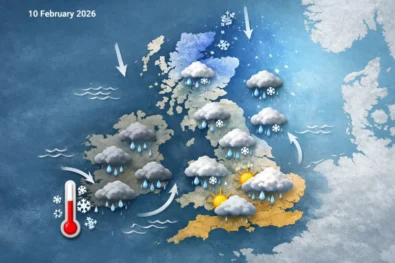
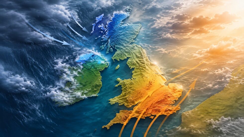
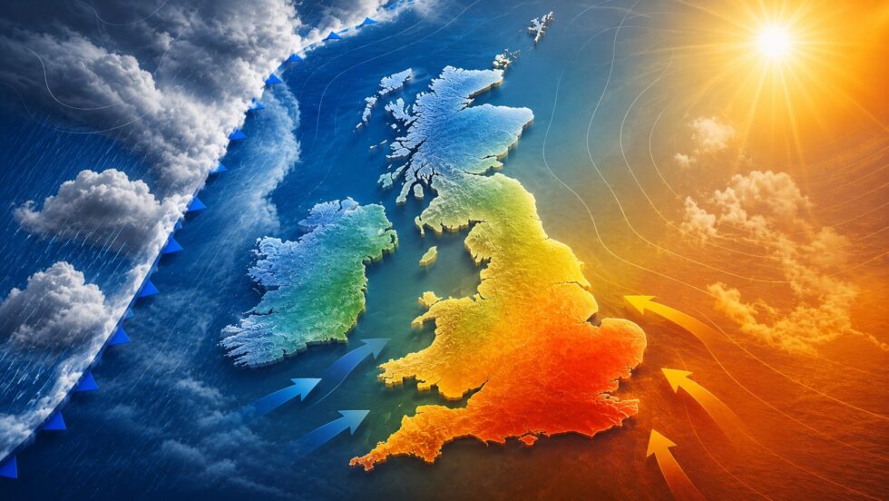
The cold conditions observed in early-to-mid May have been driven by persistent northerly winds transporting Arctic air across the UK. This has kept temperatures several degrees below seasonal averages, with daytime highs limited to 9–14°C and an elevated risk of overnight frost in exposed and rural areas. From 17 May onward, this pattern begins to weaken as atmospheric pressure systems reorganise. High pressure shifts eastward, while low pressure develops over the Atlantic, reversing the airflow and allowing milder air from southern latitudes to spread across the UK.
Key atmospheric drivers during 17–26 May:
- Transition from northerly to southerly and south-westerly winds
- Gradual inflow of warmer air from southern Europe
- Increasing solar heating due to seasonal progression
- Reduced dominance of polar air masses
By 18–20 May, temperatures are expected to return to seasonal norms. By 21–26 May, several regions — especially London and the south-east — could exceed average values.
How warm London and southern England could get by 23–26 May
Forecast models indicate that London and southern England will experience the strongest warming during the 23–26 May window, when southerly airflow becomes more established and pressure patterns temporarily stabilise. Under favourable conditions — including clear skies and sustained sunshine — temperatures could reach 24–27°C, particularly in urban areas where heat retention amplifies warming.
Temperature outlook (17–26 May)
| Region | 14–16 May (cold) | 17–20 May | 23–26 May peak |
|---|---|---|---|
| London | 10–14°C | 17–21°C | 23–26°C |
| South East England | 10–13°C | 18–22°C | 24–27°C |
| Wales | 9–14°C | 15–19°C | 20–24°C |
Even brief sunny periods during this phase could make conditions feel significantly warmer, particularly in central London due to the urban heat island effect, where nighttime cooling is limited.
Northern Ireland forecast for 17–26 May: warmer but unsettled
Northern Ireland will also see a gradual temperature increase across the 17–26 May period, though the region will remain more exposed to Atlantic systems, resulting in less stable weather conditions compared to southern England. Rain bands and cloud cover are expected to move through regularly, interrupting warmer spells and limiting peak daytime temperatures.
Expected conditions in Northern Ireland:
- Temperatures rising to 16–20°C by 20–23 May
- Frequent cloud cover reducing solar heating
- Intermittent rain, occasionally heavy or thundery
- Short sunny intervals between frontal systems
This reinforces the UK’s typical split pattern: warmer and drier in the south-east, more unsettled in the north-west.
“Rather warm” phase expected toward late May
(Dr Christopher England, meteorologist, UK) has indicated that long-range models point to a build-up of high pressure toward the final week of May, increasing the likelihood of a “rather warm” phase across the UK. The Met Office confirms that during the 17–26 May period, temperatures are expected to recover from below-average levels and may become above average toward the end of the window. Forecast progression:
- 17–19 May: cooler, unsettled conditions dominate
- 20–22 May: temperatures recover to seasonal norms
- 23–26 May: potential for warm spells and more stable weather
- Rain risk persists, especially in western regions
Will late May 2026 meet UK heatwave criteria
According to the Met Office, a heatwave requires at least three consecutive days above region-specific thresholds. Heatwave thresholds:
- London & South East: ~28°C
- Northern Ireland: ~25°C
- Northern England/Scotland: 25–27°C
Current projections for 23–26 May suggest temperatures may approach these levels but are unlikely to exceed them consistently across multiple days. Therefore, a formal heatwave remains unlikely, though short warm peaks are expected.
Rain risk across 17–26 May: instability remains key factor
Despite the warming trend, the 17–26 May period will remain influenced by atmospheric instability, particularly in western regions. Expected weather pattern:
- Sunny intervals, especially in London and the south-east
- Increasing cloud cover during afternoons
- Showers, sometimes heavy or thundery
- Localised variability across regions
This means that even during warmer days, conditions may change quickly, requiring flexible planning.
Practical guidance: how to plan during 17–26 May
The mixed weather pattern during this period requires practical adaptation across different regions.
What to do:
- London & South: plan outdoor activities for peak warmth (midday–afternoon)
- Northern Ireland: expect interruptions from rain and adjust plans
- Travel: allow for delays due to sudden showers
- Health: monitor pollen levels as temperatures rise
Key considerations:
- Carry light waterproof clothing
- Use sun protection during warmer intervals
- Prepare for rapid weather changes within the same day
Bank Holiday outlook (late May 2026): timing, risks and realistic expectations
Early indicators suggest that the late May Bank Holiday weekend (24–26 May 2026) is likely to fall within the warmer phase of the current transition pattern, as southerly airflow strengthens and pressure begins to stabilise over parts of the UK. However, this does not yet point to fully settled summer conditions. Instead, the period is shaping up as conditionally warm, where temperature gains are increasingly likely, but remain sensitive to cloud cover, frontal movement and regional exposure to Atlantic systems.
Current expectations
- Increased probability of above-average temperatures, particularly across London, the South East and parts of central England, where highs could reach the mid-20s Celsius under clearer skies
- Greater likelihood of longer dry intervals, especially compared to earlier in May, though not consistently dry across all regions
- Persistent Atlantic influence in western areas, including Northern Ireland, maintaining a risk of cloud build-up, passing showers and occasional heavier rain
- Strong regional contrasts, with the south and east more likely to experience stable warmth, while the north-west remains more changeable
What could still change before the Bank Holiday
Forecast confidence remains moderate rather than high, as small shifts in atmospheric positioning could significantly alter outcomes. Key variables to monitor:
- Position of high pressure relative to the UK
- Strength and direction of southerly airflow
- Timing of Atlantic frontal systems
- Extent of cloud cover during peak daytime heating
A more dominant high-pressure system would increase the likelihood of a dry, warm Bank Holiday, while continued Atlantic influence would result in a mixed but mild scenario. For those planning travel, events or outdoor activity, the current forecast suggests a need for flexible, region-specific preparation.
- London & South East: best chance for warm, dry conditions — suitable for outdoor plans, though sun protection may be needed
- Northern Ireland & West: prepare for interruptions from showers; plan indoor alternatives
- Coastal areas: temperatures may feel cooler due to onshore breezes despite inland warmth
- Transport & tourism: increased demand likely if warmer conditions are confirmed
If current trends hold, the Bank Holiday weekend could mark the first sustained warm spell of late spring 2026, even if it falls short of official heatwave thresholds. At the same time, the underlying pattern remains transitional, meaning that stability is not yet fully established and short-term variability will continue to define the UK weather experience.
This places the UK weather forecast heatwave Met Office outlook for late May in a critical position: a potential turning point toward early summer conditions, but still shaped by competing atmospheric forces that prevent a fully settled and predictable weather regime.
Read about the life of Westminster and Pimlico district, London and the world. 24/7 news with fresh and useful updates on culture, business, technology and city life: Virgin Media down: Why are TV channels pixelated and is Virgin Media down across the UK right now