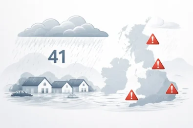
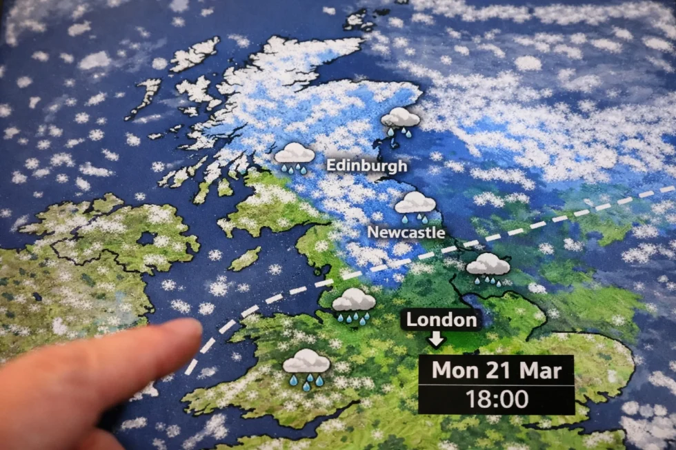
The question of whether snow could reach the capital has resurfaced after a new forecast model suggested a late-March cold push across parts of England. For readers following the UK weather forecast snow picture, the key point is clear: one widely circulated model scenario shows snow spreading south across England with flurries possibly reaching London, while the official Met Office forecast keeps the strongest snow signal over higher ground in northern and western parts of the country.
The scenario drawing attention comes from the Global Forecast System (GFS) model. One recent model run suggests snow could begin developing around 03:00 GMT on 21 March, initially affecting western England, northern regions and parts of the Midlands. By midday the same simulation indicates precipitation spreading further south, with snow or sleet possible across a corridor stretching roughly from Plymouth to Ipswich. In that projection, London sits close to the southern edge of the precipitation zone. By 06:00 on 22 March, the model output indicates snow cover could extend across parts of southern England, the Midlands, Wales, northern England, Northern Ireland and Scotland. As The WP Times reports, citing the latest outlook from the Met Office, the official forecast remains more cautious and does not currently signal a confirmed snowfall event for London.
That projection does not amount to a confirmed London snow forecast. The Met Office, which provides the United Kingdom’s official national forecast, currently describes the overall pattern as “mostly changeable”, with Atlantic weather systems expected to bring alternating spells of rain, showers and breezy conditions across much of the country. According to the latest Met Office outlook, temperatures in southern England, including London, are likely to remain close to seasonal averages for mid-March, limiting the probability of significant snowfall in lowland areas. However, the agency notes that shorter colder interludes may develop, during which overnight frost and snowfall over higher ground — particularly in northern and western regions — remain possible.
The difference between a snow model and an official forecast
Weather headlines often blur the distinction between a numerical weather model and an operational forecast issued by meteorologists. While maps showing widespread snow can quickly circulate online, they often originate from a single model simulation rather than a confirmed forecast.
A system such as the Global Forecast System (GFS) uses atmospheric data — including temperature, pressure, humidity and wind patterns — to calculate possible future weather patterns. Each model run generates one potential scenario based on those inputs. Because the atmosphere is complex and constantly changing, no single model output is treated as a definitive forecast. Before issuing an official outlook, forecasters analyse multiple model runs, compare them with observational data from satellites and weather stations, and evaluate ensemble forecasts, which test how small changes in atmospheric conditions could alter the result. This process helps meteorologists determine how likely a particular scenario — such as snow reaching southern England — actually is.
| Forecast system | Operator | Typical use |
|---|---|---|
| GFS (Global Forecast System) | US National Weather Service | Long-range global modelling |
| ECMWF model | European Centre for Medium-Range Weather Forecasts | High-accuracy medium-range forecasts |
| UK Unified Model | Met Office | National operational forecasting |
| Ensemble systems | Multiple centres | Probability and uncertainty analysis |
A single striking snow map circulating online therefore represents one potential scenario, not a confirmed weather event.
What the Evening Standard report actually says
The Evening Standard article that triggered renewed discussion about possible March snowfall does not state that London is expected to see snow. Instead, the report highlights a single model projection, based on the Global Forecast System (GFS), which shows a potential band of snow stretching across parts of England later in the month.
In that scenario, the simulated snow zone extends roughly along a south-west to east corridor from Plymouth to Ipswich, placing London close to the southern edge of the precipitation field. However, the article also notes that the Met Office outlook remains significantly more cautious, indicating that any wintry precipitation is currently most likely to occur over higher ground in northern parts of the UK, rather than across lowland southern England. This distinction is critical for interpreting the forecast. A model simulation can depict snow reaching southern England under one set of atmospheric conditions, but the official Met Office forecast is based on multiple models, observational data and probability analysis. At present, that official guidance does not indicate a widespread lowland snow event in London, and continues to place the most credible snow risk over hills and northern uplands rather than in the capital.
What the Met Office forecast shows for London
The current Met Office regional forecast for London and South East England points to typical early-spring weather rather than conditions favourable for snowfall. According to the latest official guidance, the pattern over southern Britain is being driven by Atlantic weather systems, which are expected to bring alternating spells of rain, cloud and brighter intervals.
In the short-range outlook, the Met Office says a band of rain will move eastwards overnight, clearing by early morning as drier air arrives from the west. This will be followed by breezy conditions with sunny spells, particularly during daylight hours, as pressure begins to rise behind the departing frontal system.
Temperatures in the capital are forecast to remain well above freezing, which significantly reduces the likelihood of snow in central London. The Met Office city forecast lists maximum temperatures of 14°C on Tuesday, 13°C on Wednesday, and 13°C again on Thursday. A cooler air mass is expected to arrive later in the week, with daytime highs falling to around 9°C by Friday, while overnight temperatures may drop to around 2°C. Even with that cooling trend, surface temperatures across London are still expected to stay above the threshold normally required for widespread snow accumulation, meaning precipitation in the capital would most likely fall as rain or occasional sleet rather than settled snow.cooler shift arrives late in the week.
London temperature outlook
| Date | Weather outlook | Maximum | Minimum | Snow risk |
|---|---|---|---|---|
| Tue 10 March | Dry, breezy, sunny spells | 14°C | 8°C | None |
| Wed 11 March | Bright intervals, mostly dry | 13°C | 7°C | None |
| Thu 12 March | Cloud increasing, rain later | 13°C | 6°C | None |
| Fri 13 March | Cooler with blustery showers | 9°C | 5°C | Very low |
| Fri night | Clearing skies | — | 2°C | Very low |
Even the coldest point in the short-range forecast keeps overnight temperatures around 2°C, which is generally too mild for widespread snow accumulation in central London.
Where the Met Office expects wintry conditionsWhere the Met Office sees the strongest wintry risk
The Met Office weather update published on 9 March 2026 indicates that the areas most exposed to potential wintry conditions later in the week are northern and western parts of the UK, particularly locations with higher elevation and exposure to Atlantic weather systems. According to the official update, several specific developments are expected as the weather pattern shifts:
- South-east England, including London and surrounding counties, may experience milder daytime temperatures reaching around 15°C during clearer intervals on Wednesday as relatively warm air moves in ahead of an approaching Atlantic front.
- North-west England and western Scotland are forecast to remain cooler under thicker cloud and stronger onshore winds, with daytime temperatures generally staying in the upper single digits (around 7–9°C).
- Heavy rainfall totals between 30 mm and 50 mm are possible across parts of the Lake District on Thursday, where moist Atlantic air is forced upwards over mountainous terrain, intensifying precipitation. Similar rainfall amounts could also occur in parts of western Wales and south-west England, where soils are already saturated following earlier rain.
- By Friday, a shift to north-westerly winds behind a departing low-pressure system is expected to draw colder maritime air across the UK. This transition could lead to a marked drop in daytime temperatures nationwide.
- As the colder air arrives, snow is most likely over high ground, particularly across the Scottish Highlands, the Pennines and upland areas of northern England, where temperatures at altitude fall close to or below freezing. The Met Office notes that temporary accumulations may also occur on some lower hills, especially in northern regions exposed to heavier showers.
Taken together, this guidance places the highest probability of wintry weather over upland terrain in northern and western Britain, while major southern cities such as London remain outside the primary risk zone under the current forecast scenario.
The late-March snow window forecasters are watching
The model scenario that triggered discussion centres on 21–22 March, when colder air could push south across Britain. In the GFS simulation:
- Snow appears first across western and northern areas early on 21 March
- Precipitation spreads south during the day
- London sits near the southern edge of the snow band
However, meteorologists emphasise that confidence remains low at this range. Small shifts in atmospheric pressure patterns could easily keep colder air further north or allow milder Atlantic air to dominate southern England.
Why snow rarely settles in London
Even during colder outbreaks affecting the UK, London frequently avoids significant or lasting snowfall. Meteorologists point to several structural and climatic factors that make the capital less favourable for snow accumulation compared with northern and upland regions. Several conditions reduce the probability of snow settling in the city:
- Urban heat island effect – central London is typically 1–3°C warmer than surrounding rural areas because dense buildings, roads and infrastructure store heat during the day and release it overnight. This often keeps surface temperatures above freezing even when colder air moves into the region.
- Maritime influence – southern England is strongly influenced by milder Atlantic air masses, which tend to moderate winter temperatures. Even during cold spells further north, this maritime influence can cause precipitation in London to fall as rain or sleet rather than snow.
- Ground and surface temperatures – after several mild days, road surfaces and pavements can remain well above 0°C, meaning falling snow melts on contact before it can accumulate.
- Precipitation timing and intensity – for snow to settle in London, several factors must coincide: sufficiently cold air at the surface, precipitation falling at the right time (often overnight or early morning), and snowfall heavy enough to overcome melting at ground level.
Because of these combined effects, it is common for snowfall to accumulate in rural areas of England or on higher ground, while precipitation in central London falls as rain or wet sleet and fails to settle on the ground.n.
The wording in the Met Office outlook that matters
One detail in the latest Met Office outlook is particularly important for understanding the realistic snow risk across the UK. In its official guidance, the agency indicates that frost and snowfall are most likely to occur during short colder interludes and primarily over higher ground. In meteorological forecasting, wording like this is deliberate. By highlighting the possibility of hill snow, forecasters are signalling that any meaningful snowfall is expected mainly across upland terrain, where temperatures drop below freezing more easily than in lowland urban areas. For readers interpreting the forecast, that language points to several practical conclusions:
- Snow risk is concentrated over higher ground, including upland areas of northern England, Wales and Scotland.
- Lowland snowfall is not currently a central forecast scenario, as the outlook does not mention settling snow across southern England.
- Forecast confidence beyond the short range remains limited, meaning the late-March pattern could still shift as new model runs arrive.
When the Met Office expects snowfall capable of affecting large cities or major transport routes, its forecasts normally use clear operational wording that points to lowland snow or potential disruption. In such cases the guidance typically refers to snow reaching lower elevations in southern England or warns that snowfall could affect travel conditions. None of those signals appear in the current outlook. Instead, the forecast continues to emphasise frost and snowfall mainly over higher ground, which places the greatest wintry risk across northern and upland parts of the UK rather than in London or other major cities in southern England.
What London readers should realistically expect
For commuters, travellers and residents in the capital, the current Met Office guidance points to a typical early-spring pattern rather than a clear snowfall setup. Southern England remains under the influence of Atlantic weather systems, which tend to bring variable conditions rather than prolonged cold. The forecast for London over the coming days suggests:
- Bands of rain moving through at times, followed by brighter spells
- Occasionally breezy or windy conditions, particularly as frontal systems pass eastwards
- A cooler change later in the week, as winds shift more north-westerly
- Daytime temperatures remaining above freezing, reducing the likelihood of snow settling in the city
This type of pattern is common in March, when colder air occasionally reaches the UK but often struggles to remain established over southern England for long. While snow cannot be ruled out completely later in the month if colder air pushes further south, the latest official outlook does not currently support predictions of significant or disruptive snowfall in London.
The most accurate answer today
So will it snow in London? At this stage, the available forecast data suggests the risk remains possible but uncertain. One scenario from the Global Forecast System (GFS) model indicates that colder air could push south across the UK around 21–22 March, with snowfall developing across parts of England. In that projection, a band of wintry precipitation extends into sections of southern England, placing London close to the southern edge of the potential snow zone. However, the Met Office official forecast takes a more cautious view. Current guidance continues to place the most credible snowfall risk across northern regions and higher ground, where colder air and elevation increase the likelihood of snow. For London and the wider south-east, the outlook still points primarily to periods of rain, breezy conditions and a cooler turn later in the week, rather than a confirmed snowfall event affecting the capital.
Read about the life of Westminster and Pimlico district, London and the world. 24/7 news with fresh and useful updates on culture, business, technology and city life:International Women’s Day 2026 in London and Britain: Why 8 March Still Shapes Policy, Business and Society