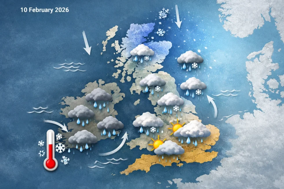
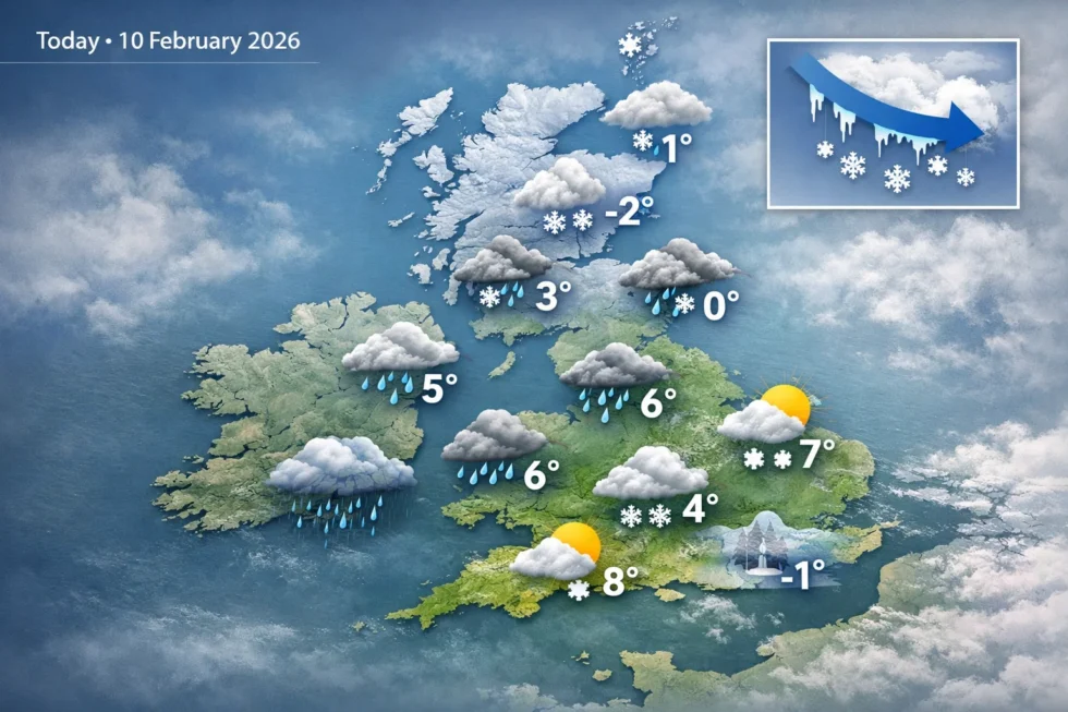
Today, Wednesday 11 February 2026, the UK weather forecast confirms a turning point after weeks of relentless rain, with colder air beginning to push south and a defined risk of snow developing from late Friday into the weekend. According to official guidance, the highest ongoing impacts remain concentrated across southern England and north-eastern Scotland, where ground saturation and flood sensitivity are already extreme, while upland areas of Scotland, northern England and Wales are entering a moderate wintry risk window as temperatures fall. The WP Times reports, citing the Met Office, that although no widespread severe cold warning is currently in force, meteorologists describe the late-week pattern change as the first credible breakdown of the entrenched wet regime that has dominated much of winter 2025–26.
What the Met Office confirms about this winter so far
The Met Office states that much of the winter to date has been shaped by a south-displaced jet stream, a configuration that has repeatedly funnelled Atlantic low-pressure systems across the same corridors of the UK. This has concentrated the heaviest and most persistent rainfall over southern England and north-eastern Scotland, leaving soils fully saturated well before mid-February.
In several river catchments, cumulative winter rainfall has already exceeded seasonal averages, meaning the landscape now reacts rapidly to even modest additional rain. The Met Office stresses that the impacts have been driven less by isolated extreme downpours and more by the sheer persistence of unsettled weather, with little opportunity for catchments to recover.
Early-week conditions: rain dominant, but thermal contrast increases
Through Wednesday and into Thursday, low pressure remains influential, keeping much of the UK unsettled. Bands of rain continue to move across northern and western areas, while southern England and Wales experience milder air drawn in on south-westerly winds.
Weather warnings remain active in parts of eastern Scotland, where flood risk remains elevated due to repeatedly saturated ground. Elsewhere, short-lived drier interludes are possible, but the Met Office emphasises these are unlikely to be prolonged. A key feature at this stage is the growing temperature divide. While daytime values in the south remain close to or slightly above the February average, northern areas increasingly feel a colder influence as winds veer more northerly and easterly.
Midweek transition: colder air starts to push south
By midweek, the Met Office identifies the first tangible signs of a broader atmospheric shift. Colder air sourced from Scandinavia begins to influence northern Scotland, gradually edging southwards. Across higher ground — particularly the Grampians and Scottish Highlands — precipitation increasingly falls as snow rather than rain. At lower elevations, rain remains dominant for now, but freezing levels continue to drop. Northern England and Wales remain largely wet during this phase, though forecasters note that the background air mass is steadily cooling, laying the groundwork for more widespread wintry conditions later in the week.
Late week outlook: snow risk increases from Friday
The most significant change is expected from Friday 13 February onwards. The Met Office confirms that the long-standing blocked pattern — which has repeatedly stalled low-pressure systems near the UK — begins to weaken. As this occurs, colder air sinks further south across the country, causing temperatures to fall below seasonal norms in many regions. Freezing levels lower sufficiently for rain to turn to snow, initially across higher ground but potentially reaching lower elevations later on Friday. Snow risk is highest across:
- Scotland, particularly upland and inland areas
- Northern England, including the Pennines
- North and mid Wales, especially away from coastal fringes
Overnight temperatures may fall to –4°C to –6°C in rural areas, increasing the likelihood of snow settling and creating icy conditions on untreated roads.
Regional focus: Wales and northern England
Wales is highlighted as a key transition zone. As rain fronts move south-east and encounter colder air, there is a growing chance of rain turning to snow, especially over hills but also locally at lower elevations inland. Northern England faces a similar setup, with the Met Office warning that timing and intensity remain uncertain, but the overall risk window for disruptive weather is now clearly defined late Friday into early Saturday. Forecasters stress that small shifts in frontal positioning could significantly affect where snow falls, reinforcing the need for close monitoring of updated forecasts.
Weekend outlook: brief improvement before Atlantic systems return
Colder air is expected to linger into Saturday, delivering the most settled conditions seen for several days and offering a temporary pause after a prolonged spell of rain. As the final rain-bearing systems clear eastwards overnight Friday into Saturday, a weak ridge of high pressure is forecast to build from the west, allowing many areas to experience a drier, brighter and calmer start to the weekend.
According to guidance from the Met Office, this improvement is likely to be most noticeable across central and southern England, where sunshine and lighter winds may develop. Northern and western regions remain cooler, with clearer skies increasing the risk of overnight frost, particularly in rural inland areas. Minimum temperatures close to –3°C to –5°C are possible in sheltered locations where skies clear for long periods.
Despite the calmer conditions, forecasters stress that this is not a sustained pattern change. By late Sunday and into early next week, Atlantic systems are expected to reassert control, pushing milder but unsettled air back across the UK. While daytime temperatures may recover slightly, the Met Office warns that flood sensitivity remains high nationwide, as catchments have had little opportunity to dry after weeks of above-average rainfall.
Weekend weather breakdown (Saturday to early next week)
| Period | Dominant pattern | Rainfall | Temperatures | Key risks |
|---|---|---|---|---|
| Saturday (daytime) | Temporary high-pressure ridge | Mostly dry for many | Below average, cool | Icy patches early |
| Saturday night | Clearer skies inland | Dry | –3°C to –5°C locally | Frost, ice |
| Sunday | Pressure falling from the west | Rain spreading later | Slowly rising | Localised disruption |
| Early next week | Atlantic systems return | Frequent rain | Near or slightly above average | Renewed flood risk |
Read about the life of Westminster and Pimlico district, London and the world. 24/7 news with fresh and useful updates on culture, business, technology and city life: Why are vitamin D users in the UK warned to stop supplements when these symptoms appear