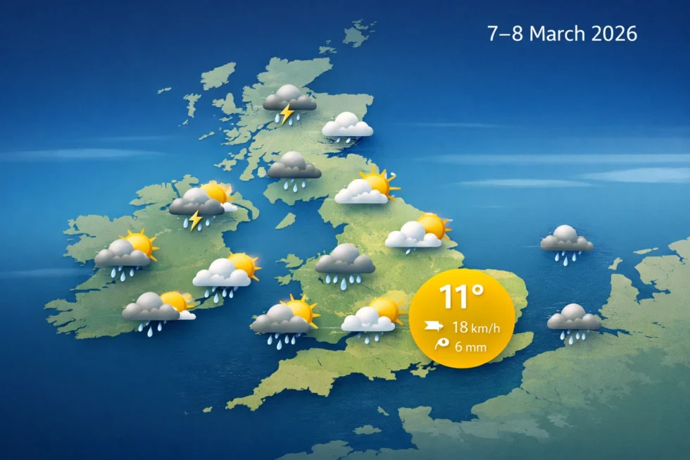
A cool and slightly unsettled Atlantic air mass will shape the weather forecast across the United Kingdom during the weekend of Saturday 7 March and Sunday 8 March 2026. The overall weather pattern will bring a mixture of cloud, occasional sunshine and scattered showers to several regions of Britain. Daytime temperatures will remain close to seasonal averages for early March, although brisk westerly winds may make conditions feel cooler in exposed areas and along the coast.
Across London and south-east England, the weekend weather will begin with overcast skies and occasional light rain early on Saturday morning before brighter intervals develop through the afternoon. Winds will strengthen slightly through the day, particularly along the Thames corridor and across coastal counties in Kent and Sussex. Sunday is expected to start with clearer skies but may bring isolated showers later in the afternoon as another weak Atlantic disturbance crosses southern Britain.The WP Times reports that meteorologists monitoring the London weather forecast for 7–8 March say the weekend weather will feel distinctly early-spring rather than wintry, although evening temperatures will still drop quickly after sunset.
Meteorological models indicate that the broader UK weather forecast will be influenced by a low-pressure system tracking across the North Atlantic toward Scotland. This system will push bands of moisture across western Britain while eastern regions, including London, experience longer dry spells. The interaction between Atlantic airflow and cooler air over the British Isles explains the variable cloud cover, intermittent showers and moderate winds expected in the national weather pattern this weekend.
UK weather pattern and weather forecast for the weekend
The overall weather forecast pattern across Britain reflects the seasonal transition from winter toward spring. During early March the jet stream frequently shifts across the North Atlantic, allowing alternating periods of maritime Atlantic air and slightly cooler continental influences.
For the weekend of 7–8 March 2026, weather models indicate the jet stream will remain north of the UK but active enough to push weak frontal systems across the country. These weather systems will primarily affect Scotland, Northern Ireland and western England, while the southeast of England — including London — should experience longer dry periods.
Key factors shaping the weekend weather forecast include:
- Atlantic low pressure approaching Scotland
- South-westerly winds bringing moist maritime air
- Passing weak weather fronts producing scattered showers
- Short clearer intervals between cloud bands
This type of weather pattern typically produces rapidly changing skies rather than continuous rainfall. In practice, many locations across Britain may experience sunshine, cloud and brief showers within the same afternoon. Temperatures will remain typical for early March. Average daytime values in southern England generally sit between 9°C and 12°C, while overnight temperatures fall to 3–5°C in rural areas.
London weather forecast for Saturday 7 March 2026
According to the London weather forecast, Saturday will begin under a blanket of mid-level cloud drifting north-east from the Atlantic overnight. Some districts of London may experience light drizzle during the early morning hours, particularly between 07:00 and 10:00 GMT, although rainfall amounts are expected to remain minimal. By late morning the cloud should gradually break, allowing brighter intervals across central London including Westminster, the City and Canary Wharf. Typical Saturday weather conditions in London:
- Maximum temperature: around 11°C
- Morning temperature: about 6–7°C
- Wind: south-west 15–25 km/h, gusts up to 35 km/h
- Rain probability: around 30–40% during early morning
Humidity will remain moderate and occasional sunshine during the afternoon should make conditions feel relatively comfortable for outdoor activities compared with colder weather earlier in the week. By 21:00 GMT, temperatures across most parts of London are expected to fall to around 7°C, with partial clearing developing overnight.
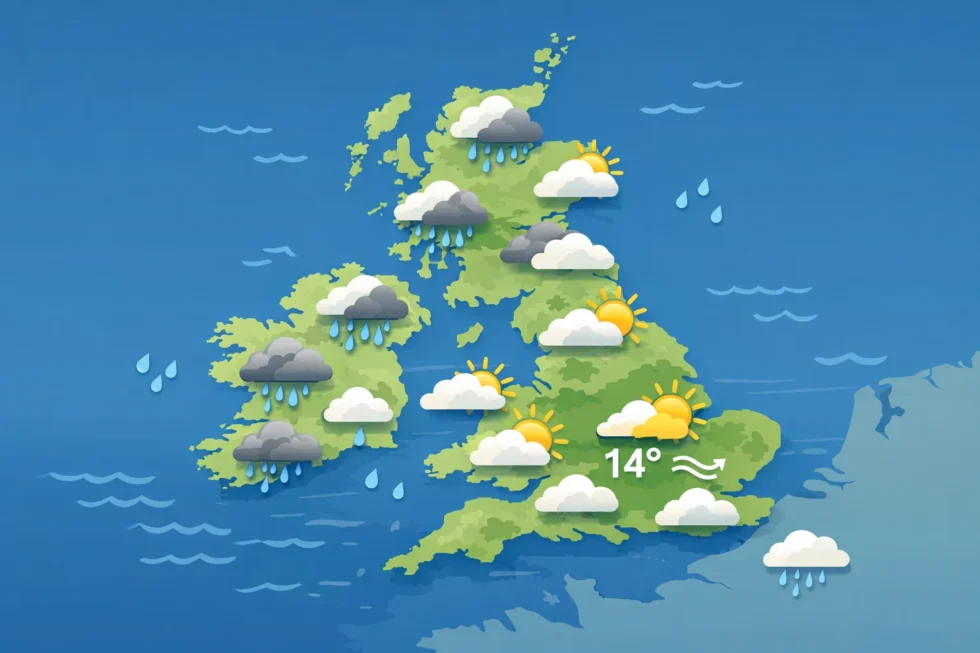
London weather forecast for Sunday 8 March 2026
Sunday's London weather forecast suggests a brighter start across much of southern England. Overnight clearing behind Saturday’s weak weather front should allow patchy sunshine during the morning hours across London and surrounding counties including Kent, Surrey and Essex. However, by late morning a new band of unstable air moving from the west may trigger scattered showers across parts of the south-east. These showers are expected to be brief and unevenly distributed. Meteorologists expect the following Sunday weather conditions in London:
- Morning temperature: around 5–6°C
- Afternoon high: 10–11°C
- Wind: south-west 20–30 km/h
- Rain risk: 40–50% during the afternoon
Cloud cover will gradually increase later in the afternoon as another Atlantic disturbance approaches western Britain. Despite the showers, the overall weather forecast does not indicate prolonged rainfall. By Sunday evening temperatures should fall again to around 6°C in London and 3–4°C in rural areas outside the capital.
Weather across England, Scotland, Wales and Northern Ireland
While London will experience relatively stable conditions, the broader UK weather forecast shows stronger Atlantic influence in western and northern regions. Areas facing the Atlantic Ocean will receive more frequent showers as weather fronts move eastward across Britain.
Scotland
Scotland will sit closest to the incoming low-pressure system. As a result, the weekend weather will bring thicker cloud and more persistent rainfall in western regions.
Expected Scottish weather:
- Daytime temperatures: 7–9°C
- Frequent showers, particularly in western Scotland
- Wind gusts: up to 50 km/h along exposed coasts
Northern Ireland
Northern Ireland will experience variable cloud cover with occasional showers.
Weather outlook:
- Temperatures: 9–10°C
- Passing rain bands from west to east
- Moderate south-westerly winds
Wales
The Welsh weather forecast indicates slightly wetter conditions than eastern England due to direct exposure to Atlantic airflow.
Typical weekend conditions:
- Temperatures: 9–11°C
- Showers more frequent Saturday evening
- Wind gusts: up to 40 km/h
Northern England
Cities such as Manchester, Leeds and Newcastle will see mixed cloud and scattered showers during both weekend days.
Expected weather range:
- Temperatures: 9–10°C
- Occasional rain showers
- Variable cloud with brief sunny intervals
UK weekend weather overview
| Region | Saturday 7 March | Sunday 8 March | Temperature Range |
|---|---|---|---|
| London & South-East | Cloudy morning, brighter afternoon | Sunshine early, scattered showers later | 6–11°C |
| South-West England | Cloud and showers | Occasional rain bands | 7–11°C |
| Midlands | Mixed cloud and sun | Brief showers | 6–10°C |
| Northern England | Variable cloud | Intermittent showers | 5–10°C |
| Wales | Showers at times | Cloud and drizzle | 7–11°C |
| Scotland | Frequent rain in west | Windy with showers | 5–9°C |
| Northern Ireland | Cloud and showers | Showery spells | 6–10°C |
Wind and atmospheric pressure trends
Weekend weather conditions will be influenced by the pressure difference between Atlantic low pressure near Scotland and higher pressure over continental Europe. This gradient will generate south-westerly winds across most of the UK, bringing moist maritime air. Expected wind conditions:
- Average wind speed: 20–30 km/h
- Stronger gusts in western Britain: up to 50 km/h
- Calmer winds in south-east England, including London
Atmospheric pressure will fluctuate between 1005 and 1015 hPa, typical of unsettled early-spring weather patterns across Britain.
Night temperatures and early-spring weather conditions
Early March nights remain cool across the UK, especially where skies clear.
Expected overnight temperatures:
- London: 5–7°C
- Southern England countryside: 3–5°C
- Northern England: 2–4°C
- Scotland: 1–3°C
These values reflect the transitional nature of spring weather across Britain. Daytime temperatures increasingly reach double digits while nights still cool rapidly after sunset.
What the weather means for weekend activities
For many people across the UK the weekend of 7–8 March marks the start of early spring outdoor activities. The weather forecast suggests generally manageable conditions for travel, walking and city sightseeing, although occasional showers may interrupt plans in western regions. In London, parks such as Hyde Park, Regent’s Park and Hampstead Heath should see extended dry periods suitable for walking or cycling. Across southern coastal areas including Brighton and Dover, brisk south-westerly winds may create a noticeable wind-chill effect near the sea. In western Britain, including Wales and parts of Scotland, visitors should expect more frequent showers and may require waterproof clothing.
Read about the life of Westminster and Pimlico district, London and the world. 24/7 news with fresh and useful updates on culture, business, technology and city life:International Women’s Day 2026 in London and Britain: Why 8 March Still Shapes Policy, Business and Society