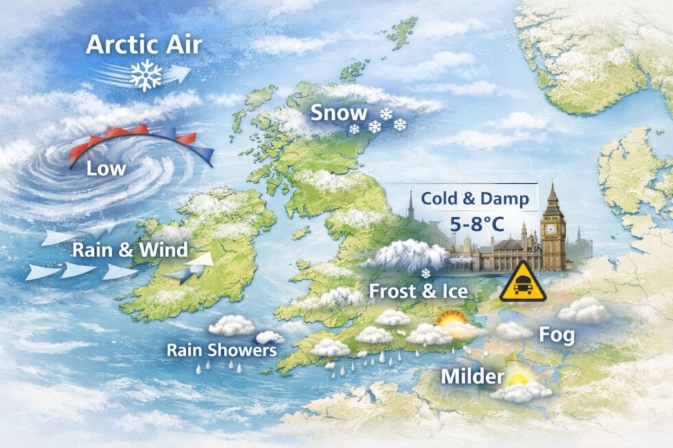
From Monday 16 February to Sunday 22 February 2026, the United Kingdom enters a meteorological transition week, rather than a clear break from winter conditions. The Arctic maritime air mass responsible for recent UK snow and ice warnings does not disappear suddenly. Instead, it weakens gradually, while cold air remains trapped near the surface, particularly during overnight and early morning hours.
This vertical temperature split creates a misleading weather pattern across Britain, combining cold mornings, icy ground conditions, frequent Atlantic-driven rain and only limited snowfall, especially away from high ground. According to guidance from the Met Office, ground temperatures remain slow to recover, increasing the risk of black ice and reduced road grip even as daytime air temperatures edge higher. As a result, the UK experiences a shift from visible winter disruption to hidden late-winter hazards, with ice posing a greater risk than snow for commuters and drivers. This is reported by The WP Times, citing the Met Office forecast outlook for mid-February.
Is the Arctic blast really ending — or just evolving
From a meteorological standpoint, this is not a clean return to mild Atlantic winter weather. Instead, the UK is entering a hybrid late-winter phase, where the cold air mass retreats aloft (in the upper atmosphere) but lingers near the surface, particularly inland and away from coastal moderation. This vertical temperature split is crucial for understanding why conditions on the ground continue to feel wintry despite less dramatic forecasts.
The practical impact is that ground temperatures remain suppressed, even as daytime air temperatures edge upward. Because road surfaces, pavements and soil warm far more slowly than the air above them, many of the most disruptive hazards — black ice, frozen patches, poor grip and overnight refreezing — persist well after snowfall has faded from forecasts. In real-world terms across Britain:
- Snowfall risk drops sharply outside high ground in Scotland and northern England, as air temperatures increasingly sit above freezing during the day.
- Ice risk remains elevated, especially overnight and during early mornings, when clearing skies allow rapid surface cooling and refreezing.
- Rain becomes the dominant precipitation type, but falling onto cold or partially frozen surfaces, it significantly increases the risk of slips, vehicle skidding and reduced braking efficiency.
In short, the Arctic influence is weakening, not disappearing. Winter disruption shifts from visible snow to less obvious but often more dangerous ice-related hazards, particularly for commuters, drivers and pedestrians during the start and end of the day.
What “Arctic maritime air” actually means — and why it still matters
An Arctic maritime air mass forms over the high North Atlantic and Arctic seas before travelling south towards the UK on northerly or north-westerly flows. Unlike continental Arctic air, which is cold, dry and often brings clear skies, Arctic maritime air is moist, unstable and highly variable. As it passes over relatively warmer ocean waters, it picks up heat and moisture, making it particularly efficient at generating wintry showers, sleet and sudden temperature swings, even when surface air temperatures sit slightly above 0°C.
This distinction is critical for understanding the current weather pattern. Arctic maritime air does not need deep freezing conditions to cause disruption. Its instability means precipitation can fall as rain one moment and sleet or wet snow the next, while rapid clearing behind showers allows temperatures to drop sharply overnight. Between 16 and 22 February, this air mass:
- Withdraws northward in stages, rather than collapsing abruptly, allowing cold air to linger close to the ground
- Remains influential across eastern and inland parts of Britain, where weaker Atlantic influence limits overnight warming
- Keeps soil, road and pavement temperatures suppressed, significantly increasing the risk of refreezing after rain
This is why snowfall becomes increasingly rare away from high ground, while black ice remains one of the dominant hazards of the week — particularly on untreated roads, bridges, cycle paths and shaded pavements that receive little daytime solar warming. In effect, the Arctic maritime influence shifts from producing visible winter weather to creating hidden, high-risk conditions, where surfaces freeze silently overnight despite daytime readings that suggest milder weather.
UK-wide weather outlook: 16–22 February at a glance
Across the United Kingdom, the period from 16 to 22 February marks a transition rather than a reset in the winter pattern. The dominance of Arctic air weakens, but it is replaced not by sustained mild conditions, rather by an Atlantic–cold air interaction that keeps weather changeable and, at times, deceptively hazardous. While widespread snowfall becomes increasingly unlikely, cold ground temperatures, frequent rain and overnight refreezing continue to shape day-to-day impacts.
For much of the country, this means sharper contrasts between night and day. Mornings remain cold with frost or ice away from coasts, while afternoons feel slightly less wintry, especially in western regions exposed to Atlantic airflow. Eastern and inland areas retain colder nights for longer, prolonging ice risk even as daytime temperatures slowly recover.
In practical terms, the week divides into two broad phases: an early period dominated by cold starts and residual wintry hazards, followed by a later phase that feels milder but brings more rain, wind and surface-level risks. Snow becomes increasingly confined to high ground, while ice and reduced grip emerge as the primary concerns for travel, commuting and outdoor activity across England, Scotland, Wales and Northern Ireland.
Early week: Monday to Wednesday
- Cold, frosty mornings inland
- Rain spreading east from the Atlantic
- Snow confined to Scottish Highlands and northern hills
- High ice risk at dawn and after dark
Late week: Thursday to Sunday
- Slightly milder daytime air
- More frequent rain and stronger winds
- Reduced frost frequency, but cold ground persists
- Ice still possible where skies clear overnight
Despite Atlantic influence, temperatures remain near or below seasonal average, especially away from southern coasts.
London weather forecast: subtle changes, persistent risks
For London and the South East, the defining feature of the 16–22 February period is not snowfall but sustained pressure on urban infrastructure caused by cold, damp and only slowly moderating conditions. While the capital largely avoids disruptive snow events, the combination of low overnight temperatures, frequent rainfall and cold ground surfaces creates a prolonged risk environment that is often underestimated in city forecasts.
London’s dense road network, bridges, cycle lanes and pedestrian areas are particularly vulnerable to black ice formation, especially during early mornings and late evenings. Even modest rainfall can become hazardous when it falls onto surfaces that have not fully warmed, while repeated wet–dry cycles accelerate wear on transport infrastructure and increase the likelihood of minor but widespread travel disruption. In effect, the week brings low-visibility winter risk rather than high-impact weather: fewer dramatic warnings, but a sustained need for caution among commuters, drivers and cyclists, as conditions remain marginal for safe travel despite daytime temperatures that may appear relatively mild.
Expected conditions in London:
- Daytime highs: 5–8°C
- Night-time lows: 0–2°C, locally below freezing
- Precipitation: Mostly rain, occasional early-week sleet
- Primary hazard: Black ice, especially on bridges and residential streets
Urban heat prevents widespread snow, but wet surfaces combined with sub-zero nights mean slip and fall risks remain elevated, particularly during morning commutes.
Detailed UK forecast: day-by-day breakdown
The detailed UK forecast for 16–22 February highlights how Britain moves through a step-by-step late-winter transition, rather than a single decisive change in weather. Each day reflects a slightly different balance between retreating Arctic air, incoming Atlantic weather systems and lingering cold ground conditions, which remain central to travel safety, ice formation and overall disruption. For readers searching UK weather this week, February weather forecast UK or will ice continue after snow, the key takeaway is that risks evolve daily — shifting from frost and ice early in the week to rain, reduced grip and wind-related issues later on.
From Monday through Wednesday, the forecast is dominated by cold mornings, overnight frost and intermittent wintry hazards, particularly inland and in northern regions. From Thursday onwards, Atlantic systems take greater control, bringing milder air aloft but more frequent rain and stronger winds, while ground temperatures lag behind. This day-by-day breakdown explains why UK weather impacts vary sharply by time of day, with early mornings consistently posing the greatest risk even as daytime conditions improve.
Monday 16 February
Cold, overcast and unsettled. Rain spreads east across England and Wales, turning to snow only over higher ground in northern England and Scotland. Inland frost widespread at dawn, raising early travel risks.
Tuesday 17 February
Rain clears eastwards, introducing a colder, showery pattern. Snow showers persist over Scottish hills. England and Wales turn drier but experience another sharp overnight temperature drop.
Wednesday 18 February
A brief calmer window. Clearer skies overnight allow radiative cooling, bringing renewed frost. Ice risk increases sharply in rural areas and outer suburbs.
Thursday 19 February
A new Atlantic system arrives. Rain becomes widespread, winds strengthen in western regions. Snow restricted to the Scottish Highlands, but heavy rain over cold ground increases skid risk.
Friday 20 February
Milder air arrives aloft, but ground temperatures lag behind. Drizzle and low cloud dominate many areas. Fog possible overnight, particularly in valleys and near rivers.
Saturday 21 February
Unsettled and breezy. Temperatures edge closer to seasonal norms. Showers remain frequent, and while frost is less common, surfaces remain cold and damp.
Sunday 22 February
Gradual stabilisation. Fewer showers and more cloud breaks. Inland areas still see overnight lows capable of producing patchy ice before sunrise.
Weekly UK weather table: 16–22 February
| Day | England | London | Scotland | Main risk |
|---|---|---|---|---|
| Mon 16 | Cold rain, hill snow | Rain, icy dawn | Snow showers | Ice, travel |
| Tue 17 | Cold, scattered showers | Cloudy, cold | Snow on hills | Black ice |
| Wed 18 | Dry, frosty | Cold, dry | Frost, northern snow | Slips |
| Thu 19 | Rain, windy west | Rain | Highland snow | Wet roads |
| Fri 20 | Damp, milder | Drizzle | Showers | Reduced grip |
| Sat 21 | Showery | Breezy | Windy, cold | Local flooding |
| Sun 22 | Cloudy, cooler | Dry spells | Clearing showers | Overnight ice |
Why it feels colder than the forecast numbers suggest
A frequent question from readers searching “why does it feel colder than the forecast UK” is why conditions remain uncomfortable even when thermometers show 7–8°C. This is not a forecasting error, but a well-understood late-winter effect driven by surface physics rather than headline air temperatures. Several factors combine during mid-February across Britain:
- Ground temperature lag: Soil, concrete and asphalt retain cold accumulated during earlier frosts and snowfall. These surfaces warm far more slowly than the air above them, especially after prolonged cold spells.
- Night-time refreezing: Moisture from daytime rain or melting frost frequently refreezes after sunset as skies clear and temperatures drop, creating invisible ice by morning.
- Low winter sun angle: Even on bright days, February sunlight delivers limited energy. Shaded streets, north-facing pavements and urban canyons receive little direct warming.
The result is a persistent mismatch between forecast highs and lived experience. Roads, pavements and cycle lanes can remain close to 0°C well into the day, meaning conditions feel colder and more hazardous than the numbers alone imply.
Health, travel and daily-life impacts
The easing of snowfall does not mean winter-related risk disappears. Public health guidance continues to highlight elevated vulnerability during prolonged cold spells, particularly for:
- Older adults, who are more sensitive to sustained cold exposure
- People with respiratory or cardiovascular conditions, for whom cold air can trigger symptoms
- Residents of poorly insulated or damp housing, where indoor temperatures remain low
From a transport perspective, disruption shifts away from snowdrifts towards slippery road surfaces, longer stopping distances and reduced tyre grip, especially during early morning and late evening hours. Fog becomes an additional factor later in the week as milder air moves over cold ground, further reducing visibility on rural roads and commuter routes.
Is another Arctic outbreak likely after 22 February
At present, there is no strong meteorological signal for a renewed, severe Arctic outbreak immediately after 22 February. However, atmospheric patterns over the North Atlantic remain unstable, meaning brief cold incursions remain possible before the transition to spring. Historically, late February in the UK is characterised by short-lived cold snaps rather than sustained freezes. Any further Arctic influence is more likely to be transient, producing overnight frost and localised ice rather than widespread snow events.
The bottom line for Britain and London
Between 16 and 22 February, the UK moves away from peak winter disruption but does not enter spring-like weather. Snow becomes increasingly rare, rain becomes more frequent, and ice remains the primary hidden danger, particularly in London and southern England. For commuters, drivers and outdoor workers, the practical guidance is unchanged: treat mornings with caution, allow extra travel time, and do not assume mild daytime temperatures reflect safe surface conditions. In this phase of winter, the most significant risks are often the least visible.
Read about the life of Westminster and Pimlico district, London and the world. 24/7 news with fresh and useful updates on culture, business, technology and city life: What is an annular solar eclipse — will it be visible in the UK on 17 February and what time is it