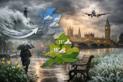
UK weather tomorrow in London is expected to stay milder than much of Britain during the weekend of 9 and 10 May as Atlantic systems bring cooler, wetter conditions across Scotland, Northern Ireland and northern England while the capital briefly holds onto warmer spring weather. The Met Office says London and the South East could briefly hold onto brighter and milder spring conditions on Saturday before cloud, showers and cooler north-westerly air gradually spread southwards into Sunday, while western and northern regions are likely to see persistent cloud bands, periods of rain and stronger coastal winds, The WP Times reports.
The latest national forecast suggests Britain is entering a more changeable mid-May pattern after several calmer and warmer days earlier in the month. Forecasters say low-pressure systems tracking in from the Atlantic will dominate the UK weather picture through the weekend and into next week, increasing the likelihood of showers, longer spells of rain and cooler daytime temperatures across much of the country. While southern England may still see dry intervals and sunshine at times, meteorologists warn that conditions could shift rapidly over short distances, particularly in coastal and elevated areas.
England weather forecast: London warmer while northern regions turn wetter
Southern England is expected to experience the most stable conditions at the beginning of the weekend. According to the Met Office, London, Kent, Essex and surrounding counties are likely to stay largely dry through much of Saturday morning and early afternoon, with temperatures potentially reaching 17C or 18C where sunny spells develop. Light winds and brighter skies may also support busy conditions in parks, outdoor venues and central London tourist areas.
However, the warmer conditions are not expected to last throughout the weekend. Forecasters say increasing cloud cover will begin pushing south-eastwards later Saturday before more unsettled conditions arrive during Sunday. Isolated showers are possible across Greater London overnight, with damp roads and reduced visibility likely during some early morning travel periods.
Northern England faces a notably different weather setup. Manchester, Liverpool, Leeds and Newcastle are expected to remain closer to active frontal systems moving across the Irish Sea and northern Britain. That increases the likelihood of cloud, patchy rain and cooler daytime temperatures ranging between 11C and 14C across many urban areas.
Meteorologists also warn of colder overnight conditions developing in rural parts of England despite relatively mild daytime readings. Under clearer skies, temperatures could locally fall towards 4C or 5C by dawn, especially away from major cities and along exposed countryside areas.

England forecast for 9–10 May
| Region | Saturday | Sunday | Temperatures |
|---|---|---|---|
| London & South East | Bright spells, mostly dry | Cloudier, showers later | 16C–18C |
| North West England | Mixed cloud and rain | Wetter and cooler | 12C–14C |
| North East England | Breezy with cloud | Cooler and damp | 11C–13C |
| South West England | Sunny intervals | Scattered showers | 14C–16C |
London weather: capital expected to stay milder for longer
London remains one of the most stable parts of Britain heading into the weekend, with the capital expected to retain milder spring air for longer than much of the UK. The Met Office forecast indicates Saturday should begin with dry conditions, occasional sunshine and relatively light winds across central and outer London.
Temperatures could approach 18C during the warmest afternoon periods, particularly across western and south-western districts of the capital. Combined with calmer conditions, that may create one of the more comfortable weather windows Britain experiences this weekend.
Despite that, forecasters stress the broader national trend is moving towards cooler and more unsettled weather. By Sunday afternoon, thicker cloud is expected to develop over London and the Home Counties, with the risk of patchy showers increasing into the evening and overnight period.
Transport disruption across the capital is not currently expected to be severe, although occasional wet roads, early mist patches and changing visibility may affect parts of the M25 network and outer commuter routes.
Scotland forecast: rain, cloud and cooler Atlantic air
Scotland is forecast to experience the most unsettled conditions in Britain during the weekend period. Weather fronts arriving from the Atlantic are expected to bring persistent cloud, frequent showers and longer spells of rain to western and northern areas.
Glasgow, Aberdeen, Inverness and parts of the Highlands are likely to remain significantly cooler than southern Britain, with daytime temperatures generally ranging between 9C and 12C. Coastal districts may also experience stronger winds, especially along exposed western shorelines and island communities.
The Met Office says rainfall could become heavier at times across elevated terrain, particularly in western Scotland where Atlantic moisture remains concentrated. Visibility may deteriorate rapidly in upland areas, creating difficult conditions for weekend travel through mountain routes and rural roads.
Meteorologists believe Scotland will be the first part of the UK to fully transition into the cooler Atlantic weather pattern expected to influence Britain through the second half of May.
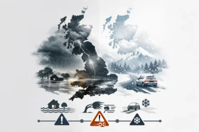
Main Scottish weather risks this weekend
- Persistent rain across western regions
- Stronger coastal winds
- Low cloud over higher ground
- Reduced visibility in upland areas
- Colder overnight temperatures
- Damp and slippery road conditions
Wales weather: mixed spring conditions with showers moving through
Wales is expected to sit between the drier southern English conditions and the wetter Atlantic systems affecting northern Britain. That means rapidly changing weather conditions are likely across many Welsh regions throughout the weekend.
Cardiff and parts of South Wales could see periods of sunshine during Saturday, although cloud bands and scattered showers are still expected to move through intermittently. Western coastal areas are forecast to feel cooler because of stronger winds coming in from the Irish Sea.
By Sunday, weather conditions across Wales are expected to become more unsettled overall, with increasing cloud cover and a higher probability of rainfall during the afternoon and evening. Temperatures are forecast to remain around 12C to 14C across most populated areas. Forecasters also note that recent rainfall has left some rural surfaces damp, meaning additional showers could quickly worsen driving conditions on smaller roads and upland routes.
Northern Ireland weather: cooler and wetter later Sunday
Northern Ireland is expected to experience a cooler and cloudier weekend compared with southern England. Belfast and surrounding eastern areas may begin Saturday with relatively calm conditions and occasional sunshine, but forecasters expect Atlantic systems to push rain into the region later in the weekend.
Temperatures are forecast to stay close to 11C–13C across much of Northern Ireland, with noticeably cooler conditions developing after sunset. The combination of cloud cover, moisture and north-westerly winds is expected to make conditions feel colder than actual air temperatures suggest. Sunday evening is likely to bring the wettest conditions of the weekend as more organised rain bands move eastwards from the Atlantic. Meteorologists say local weather conditions may still shift depending on the exact track and timing of frontal systems approaching Ireland and western Britain. Agricultural regions and coastal districts are expected to remain particularly vulnerable to prolonged damp conditions and low cloud through the start of next week.
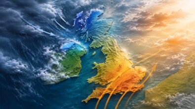
Why Britain’s weather pattern is changing again
Meteorologists say the latest change in UK weather is linked to a shift in Atlantic circulation patterns after a relatively settled opening to May. During the first part of the month, higher pressure helped southern Britain experience warmer spring conditions and lighter winds.
That pattern is now weakening as the jet stream gradually shifts closer to the British Isles, allowing cooler and wetter Atlantic systems to move back across the country. As a result, Britain is returning to a more typical late-spring setup marked by alternating sunshine, showers, cloud and sudden temperature contrasts between north and south. The Met Office says this transitional pattern could continue well into the middle of May, with forecast confidence decreasing further into next week. While some southern areas may still see brief warmer intervals, widespread settled conditions are currently not expected nationwide.
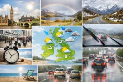
Key UK weather trends for 9–10 May
| Weather factor | Forecast trend |
|---|---|
| Southern England | Milder and brighter initially |
| Scotland | Wetter and cooler |
| Northern Ireland | Increasing rain risk |
| London | Dry spells before cloud spreads |
| Temperatures | Slightly below average nationally |
| Next week | Changeable Atlantic pattern continues |
The Met Office continues to advise travellers and motorists across Britain to monitor local forecasts closely as weather systems move through during the weekend, particularly in northern and western areas where conditions may change quickly within a few hours.
Read about the life of Westminster and Pimlico district, London and the world. 24/7 news with fresh and useful updates on culture, business, technology and city life: London Underground strike May 2026: what is happening, when and why